| The St. Michael Ley or Michael Alignment of Southern England |
Introduction
In his seminal book "View Over Atlantis" author John Michell first drew our attention to a long distant
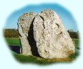
alignment that commenced on the island site of St. Michael's Mount in Cornwall,
and traveled across southern Britain linking a number of significant sites like Glastonbury Tor,
The Avebury Henge and the abbey site of Bury St. Edmunds. This alignment that has become known as the St. Michael Ley
or simply the Michael alignment plays a significant role in understanding the landscape patterns on the Marlborough Downs.
This short article looks at the alignment in depth - the sites that it incorporates -
and how it might have been established in the late Neolithic period around 2800 BCE.
View Over Atlantis
In his book "View Over Atlantis" (p. 64) Michell states:
The St Michael line of traditional dragon sites in south-west England... is remarkable for its length and accuracy.
It appears to be set between two prominent Somerset hills, both dedicated to St. Michael with ruined churches on their summit.
These two hill are Glastonbury Tor and "The Mump" at Burrowbridge some ten miles to the south-west.
Both these hills appear to have been artificially shaped so that their axis align with each other, and their orientation,
27° (degrees) north of east, can be read off a large Ordnance Survey sheet.
Michell goes on to outline the other key sites in this alignment.
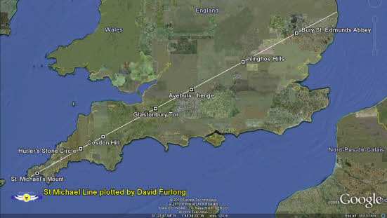
With the introduction of computer mapping both through the Ordnance Survey and Google Earth this line can now be shown in some detail and its accuracy determined.
|
| Fig 1. The Michael Alignment from St Michael's Mount in Cornwall to Bury St. Edmunds in Suffolk. |
The Alignment
This alignment when traveling from east to west broadly falls on an azimuth of around 242° (degrees). The biggest divergence from this lies in the section from The Hurlers Stone circle to St Michael's Mount, which is much closer to 238°. If this was a true Great Circle energy or dragon line as Michell suggested then I can see no good argument for this divergence. If however it was a deliberately set out alignment then a case could be made for a shift towards St Michael's Mount if it was felt that this was appropriate. My own preference is that this was a surveyed alignment because of its significance to the Marlborough Downs circles. If this is the case then the only way this could be done would be through aligning to to the high points in the landscape. How this might be done using star alignments is set out below.
Setting Out the Alignment
Setting out long distance alignments are not so difficult providing there is a sufficient number of workers and care is taken in the sighting of the alignment. The most obvious way to do this would be by sighting to the rising or setting of a specific star. It has been suggested that the Michael Line is aligned to the May Day sunrise, which is broadly on the same azimuth. This however is most likely to be coincidental as it would be nigh impossible to establish an alignment based on only one or two days a year. Stellar alignments are much more tenable.
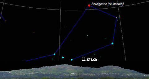
We do not know what stars might have been important in Neolithic times but one group of stars, the constellation of Orion, could well have figured in their cosmology. This group certainly were significant in Ancient Egyptian times. By watching the setting of the stars and specifically one star in the belt of Orion it would have been possible to orientate an alignment from one hilltop to the next over considerable distances. Beacon fires could have further reinforced such an alignment. The star in question is Mintaka which would have reached its extinction point on the alignment, which has an approximate azimuth of 242° around 2800 BCE. The process is quite simple. Watch on a hilltop position a clear night for the setting of Mintaka and mark that position. In daylight the alignment to another hilltop can be marked. Proceed to the next hilltop and repeat the observation, marking the sites en route.
|
| Fig.2 The star Mintaka in the belt or Orion would have set on the Michael alignment in 2800 BCE and could have provided an accurate sighting measure for setting out a long distant alignment. |
This article provides background information to the book The Keys to the Temple
The keys sites on this alignment are:
St Michael's Mount Grid Ref: SW 52456 29857
St Michael�s Mount is a small island off the coast of Cornwall where the archangel Michael is said to have appeared to fishermen in the 8th century AD.
It was once a Benedictine Priory and is now owned by the St. Aubyn family.
Carwynnen or Giant's Quoit Grid ref: SW 65006 37187
This is thought to be a late Neolithic or early Bronze Age dolmen tomb. It collapsed in an earthquake in 1967 and there intention of re-erecting this at some stage.
Ladock Church Grid Ref: SW 9446 51062
The village of Ladock is named after the patron saint of the parish church, St Ladoca.
Bofarnel Downs (Tumuli) Grid Ref: SX 11817 63367
A group of round barrows probably dating to the Bronze Age adorn the top of this hill.
The Hurler's Stone Circle Grid Ref: SX 25837 71298
An early Bronze Age monument comprising three circles aligned approximately south-southwest/north-northeast.
The name of the Hurlers stems from the legend that the three circles here were men turned to stone for sporting on the Sabbath.
The granite stones have been dressed to shape and have roughly level tops.
A floor of granite crystals was discovered in the middle ring which has a diameter of approximately 41 meters.
The Cheesewring Grid Ref: SX 25762 72478
This is an option to The Hurler's stone circle and a much more likely alignment point than the Hurler's stone circle near by. This weathered granite outcrop standing several meters high provides a very distinctive feature that could have been seen from a considerable distance and most probably from the next point on Dartmoor, the Great Links Tor.
Great Links Tor (Dartmoor) Grid ref: SX 55073 86753
This is one of the most impressive Tors on Dartmoor. From its high vantage point of 586m there are excellent views over Cornwall and extensive parts of Dartmoor. The Tor is crowned by a number of protruding granite plugs, giving it a very distinctive appearance.
Cosdon Hill (Dartmoor) Grid Ref: SX 63598 91553
The remains of five widely varying cairns can be found at the summit of Cosdon Hill, north Dartmoor, Devon. The alignment approximately follows the ridge of the hill in a north-south manner and paces close to a stone row.
West Buckland Church Grid Ref: ST 17324 20518
A Norman church dedicated to St. Mary standing in a prominent position on the western edge of this Somerset village.
Burrowbridge Mump Grid Ref: ST 35920 30528
Burrowbridge Mump is a solitary hillock sticking up out of the southern Somerset Levels. Like Glastonbury Tor its visible neighbor a church dedicated to St. Michael and probably built in Saxon times, once adorned its summit.
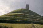
Glastonbury Tor Grid Ref: ST 51180 38603
Glastonbury Tor at the heart of Avalon, with it's remains of a church dedicated to St. Michael gracing it's summit. Glastonbury is associated with many legends including a connection with the early Christian Church. It is also reputed to be the resting place of King Arthur and his Queen Gwenevere.
Oliver's Castle (Hill Fort) Grid Ref: SU 00098 64687
An Iron Age hill fort, on the edge of the escarpment, just to the north of the market town of Devizes. Round barrows close by suggest earlier Bronze Age dating to 2000+ BCE. Close to the castle on Roundway Hill a battle was fought in the English Civil War (1643) between the Royalists and Parliamentarians resulting a defeat of the latter.
Beckhampton Long Barrow Grid Ref: SU 08704 69107
A significant Neolithic barrow dated to 3000+ BCE. The barrow is aligned approximately to the orientation of the St. Michael alignment with a northeastern entrance pointing to Avebury.
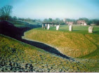
The Avebury Henge Grid Ref: SU 10269 69957
The largest henge monument in Britain dating to circa 3200 BCE. This vast complex with its many hundred stones was the centre of a well organised culture that existed in Wiltshire in the late Neolithic period. Some of the stones weighing as much as 70 tons were brought from the nearby Marlborough Downs. This area is part of a World Heritage site.
Temple Farm SU 14849 72362
Once owned by the Knights Templar from whom it derived it's name Temple Farm lies at the heart of the mystical twin circle complex that embodies the Great Pyramid design. It's post ion falls where the King's Chamber would be in the Great Pyramid design.
Drayton St. Leonard Church Grid Ref: SU 59660 96520
The small village church in Drayton St Leonard, dedicated to St. Catherine has been worshipped in for over 800 years. Much of the Nave is Norman, with two fine doorways, although the Chancel was added later. Its most striking feature is the free-standing tower, built of massive oak and chestnut beams standing within the main building and rising through the roof to a height of 43 feet.
Pitstone Church Grid Ref: SP 94224 14929
The Church of St Mary the Virgin, hidden away up an inconspicuous side road, has been closed for regular services since 1972 and is now vested in The Churches Conservation Trust.
However the attractive 13th century building is still structurally sound and occasional services take place by special dispensation.
Ivinghoe Hills Grid Ref: SP 96219 16209
Ivinghoe hills lie just to the south east of the beacon. Ivinghoe Beacon lies on one of the highest points of the Chiltern escarpment, which stretches from Goring Gap in Oxfordshire to Royston in Hertfordshire. The hillfort encompasses the entirety of the hilltop, creating a roughly triangular area. This is the start of the Icknield Path Way that leads to Knettishall Heath Country Park in Suffolk. In the other direction the Ivinghoe Beacon links to the sites in the Avebury area via the Ridgeway footpath.
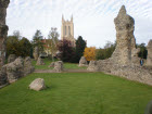
Bury St Edmunds Abbey Grid Ref: TL 85905 64254
The remains of the once great Abbey of St Edmund at Bury ruined following the Dissolution of the Monasteries in 1539, was once one of the richest Abbeys in England. Originally founded circa 633 by the first East Anglian martyr-king, Sigeberht, it later became the burial-place and shrine of the last East Anglian martyr-king, Edmund, one of the patron saints of England. The Abbey incorporated two churches St Margaret's and St James. This site is the last principal place on the alignment, which may or may not have extended further towards the coast. The projected line passes into the North Sea at the southern end of Hopton on Sea.
View the alignment in Google Earth
To view this alignment in Google Earth please click this link to download the file. Please note this is a large file and may take a little while to download. You will also need to have Google Earth installed on your computer to read the file.
The Michael Line file: Please click here
To download the main Google Earth programme: Please click here
Useful Links
follow on articles giving more details of other landscape
patterns.
Twin circles of the
Marlborough Downs explores sacred patterns of Wiltshire
Marlborough Downs
Sites a tour of the sites that make up the twin circle pattern
The Cotswold Circle an
article on a similar sized circle that over-lights the Cotswold area
The Hidden Geometry of
Avebury a look at the hidden geometry of Avebury
Silbury Hill and the Sanctuary an article on
significance of Silbury Hill and the Sanctuary
The Keys to
the Temple information on the book The Keys to the Temple by David Furlong
|
For further information please write to:
David Furlong Myrtles, Como Road, Malvern Worcs WR14 2TH
Tel: +44 (0)1684-569105 or Mobile: + 44 (0)777-978-9047
Email:
David Furlong
|
|