
Home| Keys | Profile | Tours | Courses | Books | Articles | Calendar | Contact | Links
| |
|
|
Home| Keys | Profile | Tours | Courses | Books | Articles | Calendar | Contact | Links |
||
Training Courses
Tours
Online Videos
|
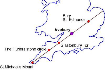
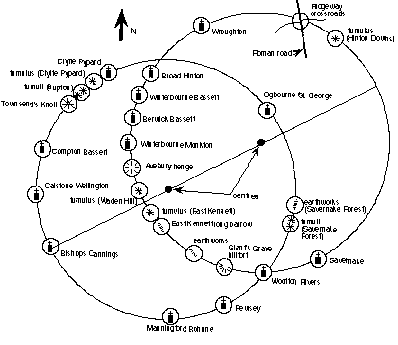
Extract based on the book The Keys to the Temple (part 1) by David Furlong Set out in the landscape of Wiltshire there is a vast geometric pattern comprising two interlocking circles which stretches over nearly seventeen miles. Even more remarkable these circles provide a clue to the hidden geometry of the most famous monument of the ancient world. For set out across the rolling hills of the Marlborough Downs is the geometric cross-sectional plan relationship with the Great Pyramid of Egypt. (See Fig 1)
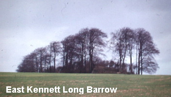
It took more than twenty-years meticulous research and the advent of the desk top computer to be able to prove beyond doubt that this pattern exists and to uncover many of the tantalising mysteries that it holds. The discovery arose from my interest in looking for alignments of ancient sites which sometimes are referred to as 'leys'. The concept of 'leys' was first proposed by Alfred Watkins in his book 'The Old Straight Track' published in 1925. Watkins suggested that ancient sites were deliberately aligned to each other as part of an ancient communication system. Watkins also included Medieval churches in his alignments, because these were often built on known pagan sacred sites. There is some evidence to support Watkin's ideas although the concept of 'leys' has not found any favour with the archaeological fraternity.In the late sixties a renewed interest in Watkins work suggested that there might be a connection between 'leys' and natural earth 'energy' currents; that it was these terrestrial 'energy' pathways that our ancient forebears were marking through their stone circles, henge monuments, tumuli, standing stones and similar sacred sites. This is a contentious area with some alignment researchers eschewing any notion of an 'energy' connection, whilst others define all 'leys' as 'energy' alignments. What all 'ley' hunters agree is that these alignments are straight, not curved and can be shown to be accurate over distances up to twenty miles. Yet here I was with my discovery of not one, but two, interlocking circles of identical size, comprising more than twenty-eight sites with radii a fraction under 6 miles and circumferences of just over 37 miles. Both circles comprise a series of individual points which includes megalithic sites such as Avebury and the East Kennett long barrow, as well as churches. In the case of the churches these have been carefully examined and large non-indigenous Sarsen stones can often be seen in their foundations suggesting the possibility that these churches were indeed built on older pagan sites. The church at Clyffe Pypard is particular significant in this respect. Nor as I was to discover are these the only two circles of this size for set out over the Cotswolds is another example Dating the Circles Corroborative evidence
So here we have two circles surveyed and set out in the landscape, very closely proportional to the size of the Earth, and containing within their geometry a cross-sectional plan of the Great Pyramid of Egypt. Setting out an alignment of sites over several miles would be quite within the known capabilities of Neolithic people; creating a circle to a set dimension, nearly twelve miles in diameter, is a very different proposition which would fully tax even the best modern surveyors. My discovery therefore seemed totally at odds with what was known about the Neolithic peoples, despite their technical skills. I was to spend the next twenty years working out how these landscape patterns might have been executed. The answers, when they came, proved to be most illuminating, resolving some enduring mysteries and showing both a simplicity as well as an amazing sophistication in how this was achieved. The peoples of Britain in the late Neolithic period were, without doubt, a highly organised and intelligent race, possessing great skills in surveying, engineering, mathematics and astronomy. © David Furlong 1998 Useful Links
follow on articles giving more details of other landscape
patterns.
|

David has been working as a healer, therapist and researcher for more than 40 years. He is the author of six books including The Healer Within and Working With Earth Energies
The definitive book on Working
With Earth Energies.
The book The Keys To The Temple from which the article is taken. Click the image for further details.
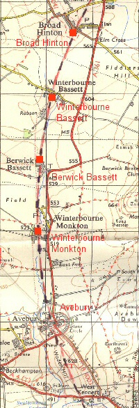
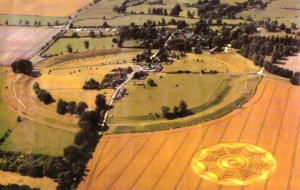
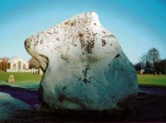
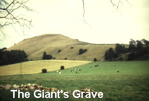
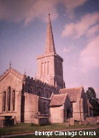
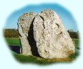
The twin circles of the Marlborough Downs Click to enlarge The four church sites of: Avebury from the air. One of the key points on the Eastern Circle. Part of the Avebury Henge The Giant's Grave: one of the points on the circumference of the Eastern Circle. The East Kennett long barrow. A key point on the Eastern Circle. Bishops Cannings Church. One of the key points on the Western Circle |
Home | Keys | Profile | Tours | Courses | Books | Articles | Calendar | Contact | Links
|
All material copyright David Furlong 2010 |
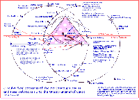
 An analysis of the geometric relationship of these circles was to show that they are connected by the same fundamental geometry as that found within the Great Pyramid of Egypt. The superimposition of a proportionally enlarged