
Home| Keys | Profile | Tours | Courses | Books | Articles | Calendar | Contact | Links
| |
|
|
Home| Keys | Profile | Tours | Courses | Books | Articles | Calendar | Contact | Links |
||
Training Courses
Tours
Online Videos
|
Introduction
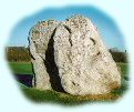
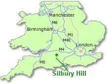
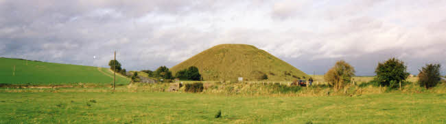
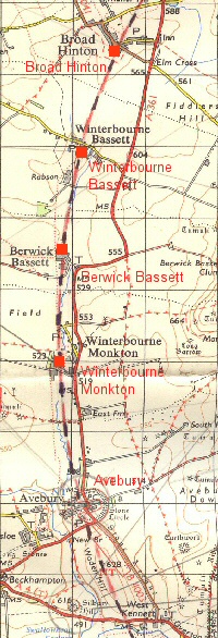
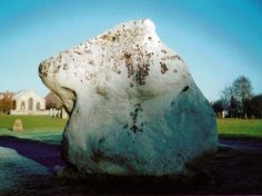
Silbury Hill
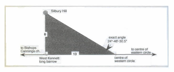
Silbury Hill has an angle of slope of 30 degrees and lies close to latitude 51 degrees 51 minutes (exact 51°-24'-58'). It would also appear that Silbury Hill was crucial to the setting out of the Marlborough Downs landscape circular leys acting as a geodetic and primary surveying point.
Surveying the Landscape By using Silbury Hill, linked to the West Kennett long barrow as a key surveying points the landscape circles of the Marlborough Downs could have been set out in the landscape. The plan below shows how this might have been donw using a rightangle triangle based on a ratio of 6:13.
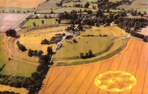
The Sanctuary Stone and Post Circle - An Astronomical Calendar?
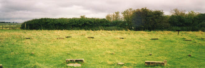
This circle comprised a series of concentric circles formed by stones and timber posts which archaeologists believe could have been a hut temple, for it marks the start of the Avenue of stones that leads to the henge monument of Avebury. In addition this site could easily have been used as a sophisticated form of astronomical calculator. The article below enlarges on this theme.
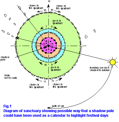
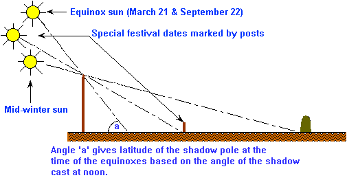
One aspect that should be noted is the number of stones and posts in each quadrant of the different circles when the site is divided into North, South, East and West. In the outer stone circle there are 21 stones in each East - West half, whilst there are 20 stones in the northern segment and 22 stones in the southern half. In the first post ring shown blue on the plan the posts increase in number from the north-western quadrant which has 7 through to the south-western which has 10. The sequence of each segment runs 7, 8, 9,10. This must have been deliberate. The following extract is taken from the book The Keys to the Temple The Marlborough Downs area includes a number of enigmatic megalithic structures. Silbury Hill is certainly one of them, but so too is the Sanctuary. This circular monument standing an the edge of the A.4 road with good views to Silbury Hill and the long barrows of East and West Kennett, comprises a number of concentric rings of both post holes and small standing stones. It is thought to have been put up in several stages commencing around 2,900 BC, with the posts supporting a thatched roof circular building, but little else is sure on the reasons for the erection of this edifice. In order to calculate the rhythm of the seasons some system needs to be established which measures the angular declination of the Sun. One way to do this is by tracking its sunrise and sun set positions as it moves across the horizon. Monuments such as Stonehenge, which indicates Midsummer sunrise, Newgrange which shows Midwinter sunrise and Maes Howe which depicts Midwinter sunset provide this function. I used to live on the western side of the Malvern Hills with extensive views out towards the Welsh Hills and in particular Hay Bluff near the town of Hay-on-Wye. During the spring and autumn months the passage of the Sun was very marked by its sunset positions as it moved forward in the Spring and back in the Autumn along the line of the distant hills. In early October and late February it set in a notch in the hills created by Hay bluff. I would often take the trouble to watch out for this moment and it was so apparent when watching the last rays of the sun dip below the horizon how powerfully this could act as both a religious experience as well as an astronomical calculator. Another way to track the movement of the Sun is with a sun dial. Placing a vertical post in the ground or on a level surface will indicate the approximate time of day (providing the sun is shining) and by measuring the length of the Sun's shadow at noon the season could also be marked. To make these necessary calculations one effectively needs a giant sundial. It so happens that the Sanctuary monument provides all of these requirements and much more. Fortuitously it does have a post hole right in the middle of the monument which we could suppose held a circular upright post with a pointed end. The monument would then become a sundial indicating the times of day, the seasons through the year and the time of the major solar configurations. In refutation of Professor Thom's Megalithic Yard Aubrey Burl cites the concentric rings of the Sanctuary as evidence that megalithic peoples did not build in multiples of these units. For as he states: "The Sanctuary with its seven concentric rings offers a unique opportunity to examine the validity of this 'yardstick' (Megalithic Yard) because consistency would be expected in the counting and measuring of these closely related rings. Yet, although a counting-base of four is manifest here from the number of posts in each ring, four is never used in the number of Megalithic Yards supposedly making up each diameter. Nor is any diameter an exact multiple of this Yard. Instead of a logical progression of 4 Megalithic Yards, 8 , 12, and so on one finds an unconvincing mixture of 4.4 Megalithic Yards, 5.0, 7.1, 11.4, 12.6, 17.2, and 23.8 Megalithic Yards." The reason for these discrepancies has, I am sure, nothing to do with the existence of the Megalithic Yard. It is, I am suggesting, because the designers of this monument were interested in marking significant dates of the year as part of their religious calendar. As the Sun travelled through the seasons so the length of the noon day shadow would either increase or decrease being at its longest at the mid-winter solstice and its shortest at the summer solstice. These concentric rings could act as calendar to indicate different dates through the year highlighted when the sun's noon day shadow touched a specific ring of the circle. Using the measurements given by Aubrey Burl for the position of the rings I carried out a number of calculations based on the position of the sun's rays for this latitude at different times of the year. Firstly I needed to establish a hypothetical length for the shadow pole. Without direct evidence this can only be an assumption, but certain factual information helped.
A Giant Sundial A hypothetical pole of this height erected at the centre of the circle would highlight, through the length of the shadow that it cast, the following dates of the year (based on our calendar.) Each date is indicated when the shadow from the centre pole at noon touches one of the rings that make up the Sanctuary monument. The Sanctuary sundial, based on this shadow pole, does not show the equinoxes nor the summer solstice however each of the four main Celtic festival dates, Imbolc, Beltane, Lugnasad and Samhain are marked. If indeed this monument acted as a calendar it supports the idea that Druidic traditions could link back to much older pre-Celtic beliefs stemming from Neolithic period. A central pole position is marked at the Sanctuary and there is nothing to disprove its use as an astronomical time piece. Indeed I would hazard that this use best fits the evidence of the enigmatic concentric rings. As a sundial the Sanctuary circle would indicate the following dates based upon the noon day sun.
In order to operate effectively the priests and priestesses of the Sanctuary would need such a timepiece for establishing a rhythm for the great Festivals that undoubtedly took place at Avebury. If they did not use the Sanctuary for this purpose, to which it was ideally suited, where did they establish their Sundial? Such ideas are speculative showing how such a calendar might have worked, rather than affirming the validity of the dates depicted. If such a pole were erected, the morning light of the Sun would cast a shadow across the circle to the great avenue of stones that leads down from the Sanctuary to the Avebury monument. Over the space of just two hours, the shadow line would open the gateway that gives access to this processional path. Through this simple means the timing of festivals and ceremonies could be judged to perfection. There are a number of other similar monuments to the Sanctuary such as the one at Durrington Walls that comprise concentric rings of wood and stone. Orthodoxy suggests that these buildings were thatched over, in which case their calendrical function would be greatly reduced, unless of course certain sections, particularly to the south, remained open to the sky allowing for specific solar alignments to be highlighted. Useful Links
follow on articles giving more details of other landscape
patterns.
|

David has been working as a healer, therapist and researcher for more than 40 years. He is the author of six books including The Healer Within and Working With Earth Energies
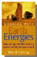
The definitive book on Working
With Earth Energies.
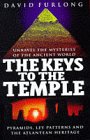
The book The Keys To The Temple from which the article is taken. Click the image for further details.
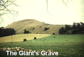
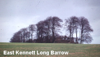
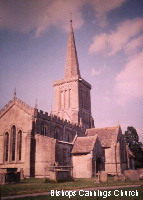
Click to enlarge The four church sites of: Avebury from the air. One of the key points on the Eastern Circle. Part of the Avebury Henge The Giant's Grave: one of the points on the circumference of the Eastern Circle. The East Kennett long barrow. A key point on the Eastern Circle. Bishops Cannings Church. One of the key points on the Western Circle | |||||||||||||||||||||||||||||||||||||||||||||
Home | Keys | Profile | Tours | Courses | Books | Articles | Calendar | Contact | Links
|
All material copyright David Furlong 2010 |