
Home| Keys | Profile | Tours | Courses | Books | Articles | Calendar | Contact | Links
| |
|
|
Home| Keys | Profile | Tours | Courses | Books | Articles | Calendar | Contact | Links |
||
Training Courses
Tours
Therapeutic Services
Online Videos
|
INTRODUCTION The Primary Pattern
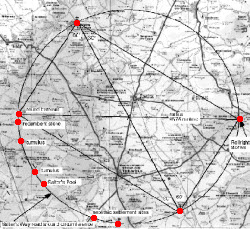
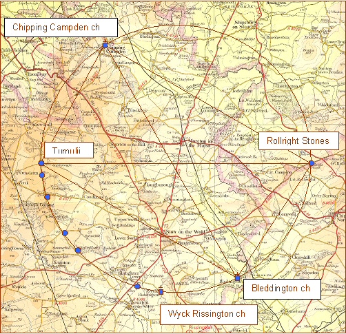
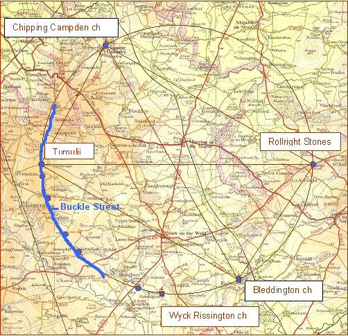
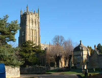
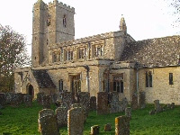
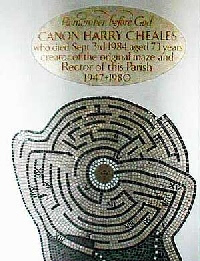
The discovery of another landscape circle was not quite a coincidence. Having found two identical circles overlaying the Marlborough Downs it was natural to look to see if others might exist in different areas. This might sound easy but in practice there are very many complications. Alignments across a single map can be readily spotted. The problem occurs when these same alignments span two maps. As has been mentioned already, the only satisfactory way to be certain of an alignment is to carry out a mathematical calculation. Perhaps in some future date a computer programme will be written that will immediately search for alignments, triangulations and circular patterns in any given area. A project of this magnitude is beyond my capacity for the moment although I would like to propose this concept being taken up as part of the archaeological departments of universities or the County Councils. In the meantime I have to make use of much simpler methods and this requires a bit of luck. To spot a circle overlaying one map is difficult enough, to discover one that spanned two or more maps is far more problematic. At the time of my discovery of the Cotswold pattern I was still working from the old 1" to the mile maps which covered a slightly greater area than the present 1:50,000 Landranger series. This slightly increased my chances he chances of finding another circle, of the same size as those on the Marlborough Downs. Nevertheless it was still a lucky discovery. What attracted my attention this time was not a series of churches, (which had led to my discovery of the first of the Marlborough Downs circles) but a road. This is a very minor road, known as Buckle Street. It that runs from Bourton-on-the-Water through to Chipping Campden. It is quite a long road, as minor roads go running for over 14 kilometres. Its striking feature is that for about 10 kilometres or 6.25 miles it sweeps in a broad arc along the ridge of the Cotswolds. It is not quite a perfect circumference curve, but very nearly so, and the radius of its arc is 9575 metres. It therefore effectively matches the size of the Marlborough Downs circles. This road has an interesting history for it was one of the ancient ‘salt-way’ tracks that probably date from the Neolithic period. Of course the road on its own would be hardly sufficient to claim a discovery of another circular pattern (see Fig. 2). Fortunately this is not the only significant feature. Church Sites Diametrically opposite Chipping Campden lies the parish church of Bledington, Dedicated to St. Leonard it was built between 1150 AD and 1175 AD. Its mellow stone walls and unusual architecture, with some distinctive gargoyle faces, give it an attractive appeal. The church notes state that it may have been built on the site of an earlier Saxon Chapel. Located at the edge of the village It too stands on rising ground and would originally have had good views to the north and west. Bledington church to Chipping Campden church is on a bearing of 331.84° (28.16.° west of true north), the reciprocal bearing is 151.84°. Being positioned diametrically opposite each other on this landscape circle is, as we shall see, highly significant. The sites are not intervisible but an alignment between them could easily have been established with no more than two intermediate positions. These two sites set a key datum alignment for the setting out the other circumference points. The church of St. Laurence at Wyck Rissington also has some interesting associations. The present church is 12th century and it too might have been built on an earlier Christian site. Just after the Second World War the church was in a very bad state of repair and closure seemed the best option. But in 1947 rector Harry Cheales took over and applying considerable zeal helped restore the church. He was something of a Christian mystic and had a vision to build a maze in the grounds of the rectory, which then became the focus for different meditation groups. Mazes, although not mentioned here previously, are another of those pre-Christian sites, which can often be found associated with 'leys'. Several mazes, dating from Celtic times, exist throughout Britain. As with other pagan symbols Christianity often incorporated them into the design of their buildings. Perhaps the most famous of the church mazes can be found set out in the floor of Chartres Cathedral showing the link between Christian and pre-Christian tradition. Sadly the Wick Rissington maze no longer exists, being destroyed when the rectory was sold into private hands. Rollright Stone Circle
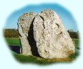
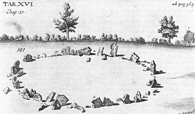
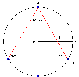
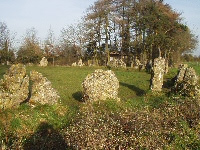
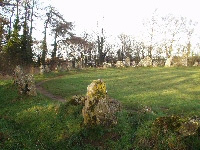
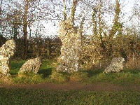
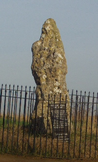
The most significant megalithic point on the Cotswold landscape circle is the Rollright stone circle, which is located almost due east of its centre point. The Rollrights, with the nearby ruins of a portal dolmen called the Whispering Knights and the solitary King’s Stone form an important group. The stone circle, itself, was originally composed of seventy-seven Cotswold stones ranging in height from being almost invisible to 2.1 metres high. Today it is very well weathered. The stones describe an almost a perfect circle, with a diameter of 31.6 metres or 38 Megalithic yards. Legend has it that these were men caught by the devil in revelry and turned into stone. The dating of this monument is thought to be contemporary with other circle sites of similar complexity which would be circa 2500 BC. In addition to the main circle and the dolmen (Whispering Knights) the Warwickshire County Council SMR (Sites and Monuments Record) lists a number of barrows within a hundred metres of so of the King’s Stone indicating the importance of this area 90 - 60 - 30 triangle Diagonally opposite the Rollrights on the other edge of the circle the Gloucestershire CC SMR (archaeological records) lists a possible group of round barrows at this position. These are not shown on the OS sheet but the site is close to Heaver Wood and I shall refer to them hence forth as the Heaver barrows. Because they lie on the diagonal from the Rollrights they too are related to the churches of Campden and Bledington. These four sites create a neat rectangle, based on two 90° - 60° - 30° triangles. Could these placements be a coincidence? I think not. 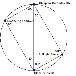
The Rollright Enigma This is one of the very simple ways of creating right-angled triangles. All they would then need to know is which ratios would be required to produce the necessary internal angles. In this particular case they could use either the diagonal from Chipping Campden to Bledington or the diagonal from the Rollright stones to the Heaver barrows. For example, let us suppose that they wished to establish another circumference point which had internal angles of 40° and 50° they would simply need to project alignments based on the angles from the two diameter sites where these two lines crossed would mark a third point on the circle. Architects and surveyors require plans from which to work. What would have been very helpful to our Neolithic surveyors would have been a ground plan from which to make their calculations. Such a plan would need to be set out as a circle, of a reasonable size to accurately check the ratios. The points could then be marked on the circumference in the positions of the intended landscape sites. Realistically it would also need to be durable against the extremes of the British weather and what better material than stone. Once the plan had been established it would act as a working scale model for the landscape surveyors. And where might such a place be? Rollright Template 3° (19:1), 6° (19:2), 9° (19:3) and 30° (19:11) or multiples thereof . The ratios are shown in brackets. These ratios are very accurate in producing the required angles. For example the 19:11 ratio is correct to within 4.2 minutes of arc.
We might therefore safely conclude, with some justification, that the Rollright stone circle was used as a template for setting out its larger version in the landscape. If we consider the Rollright stones to be a template of a larger landscape circle, the next key point to have been established would have to have been the barrows near Heaver wood which are on a bearing of 271.25°. This is very close to being exactly east-west (270°) but not quite, being 1.15° adrift. 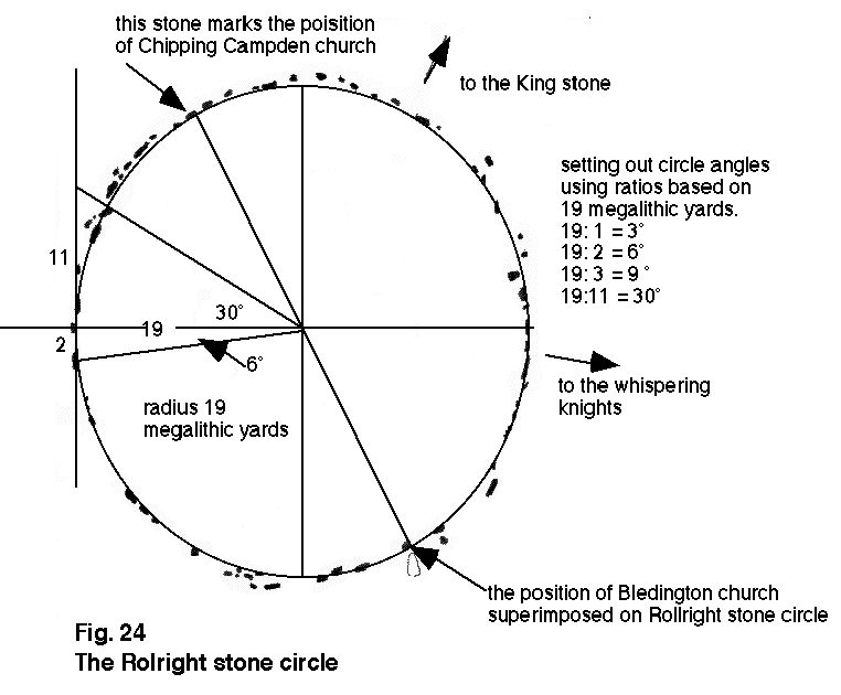
Fig 4. Plan of Rollright stones with its possible use as a template. Click to enlarge.
Astronomical Connections If we use the layout of the Rollright circle as our model for the larger landscape circle some fascinating features can be observed. The diagonal from Chipping Campden to Bledington church is on a bearing of 152°. Superimposing this bearing onto the Rollright stones we find that both the Bledington and Chipping Campden points are marked by significant stone. We do not know for certain how much the Rollrights have been damaged and what stones have been removed or repositioned but by way of assessment we can mark on the positions of all the sites on the large landscape circle to see how this fits with the stone positions of the Rollrights. Applying this technique I am now sure that the Rollrights were used as a model for the larger landscape circle. The Pattern Continues There is not space in this work to fully consider the various aspects this pattern but its existence lends substantial weight to the concept of vast landscape patterning carried out in the Neolithic period. Although these sites are not all of ancient origin, the design they display fits well with what we have already discovered from the Marlborough Downs circles. The Neolithic peoples were certainly in evidence in this area, for long barrows are scattered across the region, with a significant group focused around Swell Hill Farm and another group just to the west of Stow-on-the -Wold. The Cotswolds region is a very striking, with mellow dry stone walls bordering wide open fields. The natural stone buildings have a unique charm that makes this a very desirable place to live. One of the highest point in the area, which also sits very neatly on the circumference of our circle, is Cutsdean Hill at 305 metres above sea level. From here the land slopes gently down towards the east, cut here and there by river valleys. The ancient Roman Road the Fosse Way, runs diagonally through the centre of the circle, passing within 200 metres of the central node point. The Fosse Way is the main artery to the two principle towns to be found here. Moreton-in-Marsh, the largest is about 1.5 kilometres north of the centre, whilst the pleasant market town of Stow-on-the-Wold is a further 5.5 kilometres to the south. On the northwestern edge lies Chipping Campden, which has already been mentioned. In all a further seven key sites mark the circumference of this landscape circle in addition to the road, the churches of Bledington and Chipping Campden and the megalithic sites of the Rollrights and Heaver Wood. These additional sites include a Neolithic settlement adjoining the Fosse Way; the enigmatically named Salter's Pool with its adjoining Round Barrow and a recumbent stone on the top of Cutsdean Hill, which is the highest point in the area. The discovery of identically sized landscape circles in two distinct areas suggests that other may well have been created. This offers scope for further research into this type of patterning. The more that this research uncovers the greater must be our respect for these ancient people who wove harmonious patterns across the British landscape. The Cotswold circle like those on the Marlborough Downs, is in a similar ratio to the Earth by the enigmatic number 666. It also incorporates relationships to star patterns in its design and execution. Despite our modern technological achievements these fall short of what Neolithic people were able to achieve. A harmonious balance to the Earth © David Furlong 1998 Useful Links
follow on articles giving more details of other landscape
patterns.
|

David has been working as a healer, therapist and researcher for more than 40 years. He is the author of six books including The Healer Within and Working With Earth Energies
The definitive book on Working
With Earth Energies.
The book The Keys To The Temple from which the article is taken. Click the image for further details.
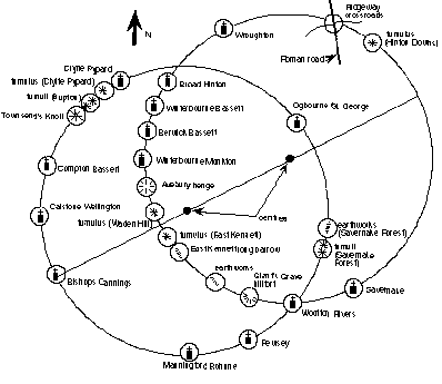
The twin circles of the Marlborough Downs relate to the equatorial circumference of the Earth by the ratio 1/666 (click image to enlarge).
 Fig 3. Alternative view of the circle in greyscale.(Click image to enlarge) www.rollrightstones.co.uk/
OS ref SP
| ||||||||||||||||||||||||||||||||||||||||||||||||||
Home | Keys | Profile | Tours | Courses | Books | Articles | Calendar | Contact | Links
|
All material copyright David Furlong 2010 |


.jpg)

