
Home| Keys | Profile | Tours | Courses | Books | Articles | Calendar | Contact | Links
| |
|
|
Home| Keys | Profile | Tours | Courses | Books | Articles | Calendar | Contact | Links |
||
Training Courses
Tours
Online Videos
|
Introduction
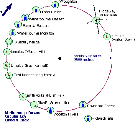
Eastern Circle
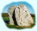
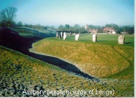
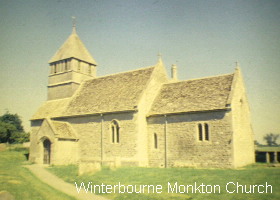
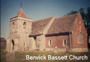
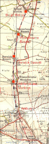
The circumference of the Marlborough Circle passes through the western side of the monument in the approximate position of the public car park opposite the post office. This part of the henge still retains many large stones, which give a good impression on how it might have looked in times past. The next group of church sites, which led to my discovery of the circles lie close to the small brook that eventually merges into the famous Kennet river. Leaving the henge by its northern gateway via the A.4361 and travelling north the first point after Avebury is the ancient church of Winterbourne Monkton . This is found by turning left at the sign about a 1.2 miles from the henge and following through to the car park alongside the farm buildings. Here can be found a small church, dedicated to St. Mary Magdalene dating to 1133 AD. There is suggestion that it marked the spot of an earlier chapel founded by some monks from Glastonbury in 928 AD. Inside can be found two unusual timber pillars, which support a square bell tower with an inset pitched roof. Outside, at its eastern end, can be seen a large recumbent sarsen stone which marks the grave of Reverend Brinsden who died in 1710 AD. This was taken from an ancient barrow just north of the church. At the western end of the church old undressed foundation stones can be clearly seen at ground level. Such stones are found in many churches and are so obvious that they suggest a deliberate intent of incorporating stones from pagan sites into the structure of the building. Inside there is an ancient font giving clues to the antiquity of the church. This receptacle is carved with chevron design and has an ancient fertility symbol on its northern face. Leave the church and turn left at the junction with the A.4361. The next site can be found by a left turn just prior to a sharp right hand bend in the road. On entering the hamlet of Berwick Bassett a sign marking the footpath way to the church can be found on the right hand side of the road. This straight trackway, covered over by trees gives a feeling of walking through a tunnel before emerging in front of the small 14th century church of Berwick Bassett dedicated to St. Nicholas . When I first saw this church twenty years ago it was derelict being made redundant in 1972. It has recently been restored by the Churches Conservation Trust. Part stone and part brick the building has a small unusual tower. Close by are some standing stones drilled to take gate posts. Whether these are old or recent I cannot tell, but an information leaflet on the church states that sarsen stones were used for grave stones at this site. The church has a 13th century font suggesting that it was built on the site of an earlier church.
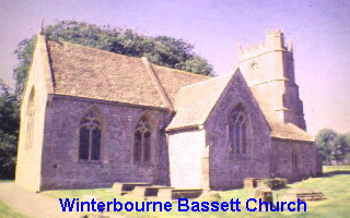
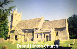
Continuing back along the A.4361 the church of Winterbourne Bassett can be found from another signposted left turn 1.2 miles from the turning to Berwick Bassett. On entering the village the church can be found via a short roadway on the left hand side. Built in stone with the earliest parts dating from around 1100 A.D it has a light airy feeling with resplendent deep red and purple stained glass windows. The church was originally dedicated to St. Katherine with St. Peter being added at a later date. A gently curving trackway leads from this church and follows the exact line of the circumference of the circle for a distance of about one mile to the next church at Broad Hinton. For those who wish to travel by car return back to the A.4361 and turn left. Take the next turning left which is signposted to Broad Hinton. The church is off this road on the left hand side and the directions are signposted. Broad Hinton church like the previous churches is fairly small although is used more frequently than the others. Surrounded by trees, including a ancient Yew, the light in the church is much more sombre and brooding reflected in the blackened oak panelling and intricate memorials to the dead. Outside there is a stone cross but its base does not suggest it is of great age. The trackway from Winterbourne Bassett can be found to the eastern side of the churchyard. Of all the churches this is the greatest distance from the calculated line, which follows the footpath. The exact crossing point, to form a 60° angle between East Kennet Long Barrow and the centre of the eastern circle is marked by a small pond close to the church way junction with the B.4041. Returning back to the main road, a white horse chalk figure can be clearly seen on the side of the downs opposite. The intersection point between the two circles lies just off the left hand side of this road in the middle of a cornfield. Access to it can be found from a bridleway about 2.4 miles along the road from the junction out of Broad Hinton.
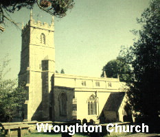
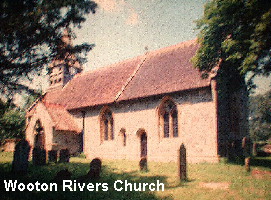
Continuing towards Wroughton the church can be found shortly after the road dips down the escarpment on the left hand side. This is a large church, dedicated to St. John the Baptist was built in Norman times. An older Saxon church is known to have stood on the site prior to 965 A.D. because it was mentioned in an Anglo-Saxon charter. There is the remains an ancient broken cross in the churchyard. There are also some old earthworks to the southwest of the church yard, which face out towards Swindon. Remains of Roman pottery have been found in the field alongside the church. The church details state: There is evidence of Christian worship on this site prior to the 10th century AD. A high point for the site would have been chosen by the Celts, possibly so it could have been seen from as wide and area as possible, to provide a landmark and to be a stronghold. The next site can be found by taking the B.4005 to Chiseldon: passing through the village to road joins the A. 345 which is the main road to Marlborough. Turn right and then first left onto a road, which was originally part of the Ridge Way track. This will take you past the large hill fort of Liddington Castle on your right. Cross the A. 419 and a short way on you will find a cross-roads with an old Roman Road called Ermin Street. Watkins noted that cross roads were often found at significant ley crossing points. Turning right and then first left to the village of Blaydon the road runs alongside the motorway. Just over half a mile up the road turn left again and cross over the motorway. A trackway will be found on the left hand side just past the bridge which leads to the round barrow (tumulus) on Hinton Downs. This is about a third of a mile up the track on the right hand side. This round barrow provides a corridor of extensive views to the south- west across the circle. A fairly large gap now occurs of nearly a quarter of the circle before the next point. This can best be found by travelling back to Marlborough and then taking the A.4 road back towards Newbury. Just out the town and up the hill a sign will be found to Savenake Forest and Tottenham House. Turn right here which will take you onto a straight road called the Grand Avenue which coincides with an ancient Roman road. Just under 1.2 miles along this road there are some earthwork embankments which mark the edge of the western circle at this point. If you parked your car here and followed these embankments for a short distance on the left hand side of the road you would be walking along the circumference to the earthworks that lie next to the A.4. In the other direction two tumuli sites can be found about one mile away although the easiest access by road is from the A.346. Continuing on for 2.2 miles you will come to a 'T' junction. Turn left here and a short way up the road a sign will indicate the way to the church. The church in Savenake Forest dedicated to St. Katherine is of recent origin being built in 1860 by the 2nd Marquis of Ailesbury for the workers of the estate and in memory of his mother-in-law the Russian countess from Voronzov in the Crimea who became duchess of Pembroke and the mother also of Sidney Herbert, Florence Nightingale's friend and patron. Unusually the aisle of this church is orientated on a west south west axis which coincides with the alignment of circumference of the circle. The next point is the church in the town of Wootton Rivers. There are a number of routes that can be taken from Savenake. The easiest route is probably by turning left from the church and taking the road to Burbage. At the end of the town turn right onto the B.3087 to Pewsey. Turn right again about a mile and a half up the road where signposted to Wootton Rivers. The church can be found, via a short road, on the left hand side. Dedicated to St. Andrew it is of ancient origin, being modified and enlarged in a number of stages. Although not included in the western circle this site lies very close the intersection between the two circles which exactly placed just to the east of the road where it crosses the Kennet and Avon Canal. If ever there was a marker at this point it would have undoubtedly been removed during the excavation work on the canal. Running close by is the railway line between Great Bedwyn station and Pewsey. Effectively three great systems of transport, car, rail and boat (communication) come together at this point. The northern intersection has no such markers being set in the middle of a cornfield close to the A.361.
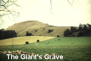
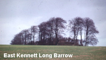
The remaining sites all date from Neolithic times and are not easy to access. The first is the spectacular promontory of the hill fort called The Giant's Grave. This can be found by taking the Marlborough Road out of Wootton Rivers and at the junction with the A.345 turning left towards Pewsey. You will have to park you car in the village of Oare and then make a fairly strenuous climb up to the hill fort. The effort is well worthwhile for from the top the views are spectacular. (For those who wish to cut short their journey and access some of the sites in the western circle please refer to the sites of Pewsey and Manningford Bohune mentioned in the western circle section.) The circumference line then passes along Huish Hill moulding to the contour of the land and its earthworks, and then on to some more earthworks at Gopher Wood. Both of these sites can only be accessed via trackways. Next point the East Kennett Long Barrow, which is on private land with no direct access. The Barrow can best be viewed from the road that leads out of East Kennet. As already mentioned its axis aligns to the circumference of the circle.
The final point is a small group of tumuli on the northern summit of Waden Hill which has also, on its lower eastern slopes, the stones of the Avenue. The tumuli are not readily accessible being on private farmland. From Waden Hill Avebury can be seen again making a total circuit of just over thirty seven miles.
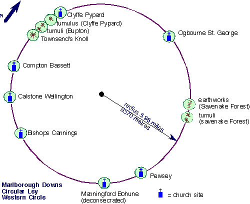
Western Circle
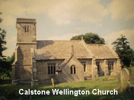
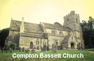
Leaving Bishops Cannings by the same road, the A.361 needs to be crossed and the road taken to Calne. After two and a third miles you will see a signposted road on the right to Calstone Wellington. The church can be found on the right hand side just through the village. This church is also dedicated to St. Mary and falls on a direct alignment between the centre of the western circle and Silbury Hill. The present church was erected in the 15th century but there is evidence for an earlier church dating to the 12th century. The next point is the church at Compton Bassett . To find this site take the Calne road out of Calstone Wellington then take the first turning right which will take you through to the A.4. When reaching this road you will need to turn left then almost immediately right towards Compton Bassett. The church is about two miles along the road on the right hand side. It is a large church dedicated to St. Swithins and like many others built on ancient foundation stones. There is some evidence of a church from Saxon times being found here. Leaving Compton Bassett the circumference of the Western Circle then remarkably follows the sweep of the escarpment, between the downs and the plain below for over four and half miles through Highway Hill, Clevancy Hill and Clyffe Hanging. Leave Compton Bassett and follow the road along the bottom of the escarpment until the sign Clevancy, then turn right. The next site of Townsend's Knoll can be found at the end of the lane on the left hand side. It is an ancient conical mound. It was excavated in 1947 but no burials found within so now thought to be natural. It could equally well have been used for surveying by using transit markers as described in Chapter 9 of Keys to the Temple. In support of this an alignment can be shown running from the Knoll to Bardenstoke Abbey - Rodbourne Church with its ancient cross - Corston Church - Foxley Green church - Leighton church - Boxwell Long Barrow a total of seven sites within a distance of twenty-eight kilometres (16.53 miles).
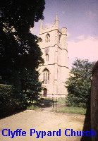
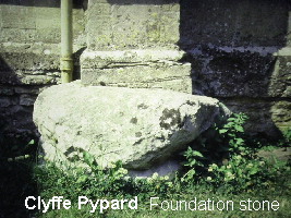
The next three sites can only be accessed by walking along the ridge foot path that leads from Clevancy to Clyffe Pypard. They are shown as tumuli and earthworks on my old 1:25,000 scale map, however the most recent pathfinder series (1:25000) have omitted them. The next site, accessible by car, is the church at Clyffe Pypard. This can be found by leaving Townsend's Knoll and returning back to the minor road that leads to Bushton. Turn right at the 'T' junction and right again in Bushton, which is about one and half miles along the road. The road is signposted to Clyffe Pypard. The church can be found from a left turn after entering the village. Like many other churches in the area ancient foundations stone can be seen which suggest some early site existed here before the church was erected. Dedicated to St. Peter the earliest parts of the present church date from the late 13th century. Close by there is a tranquil ornamental lake, which gives this site a special atmosphere. This completes the marked sites in this sector of the circle and the next place at Ogbourne St. George is nearly a quarter of the circle further on.
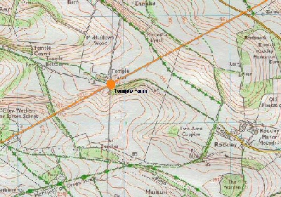
The most attractive route to get to Ogbourne involves crossing the centre of the Marlborough Downs. Turn left on leaving the church at Clyffe Pypard and left again out of the village taking the road to Winterbourne Bassett. The remains of a stone circle can be seen on the left hand side of this road about 2.8 miles further on. Passing through Winterbourne to the junction with the A. 361, turn left towards Wroughton and 0.9 miles along the road you will come to a junction signposted to Rockley and Marlborough where you will need to turn right. The road will take you up onto the highest points of the downs and provides access to the King's Chamber point at Temple Farm. After several miles (8.5 miles) you will see a signpost to Rockley. Turn left here and follow along the road until it stops at the edge of a wood. There is no vehicular right of way beyond this point but you can walk along the farm roadway to Temple Barn, a distance of just over a mile, where you will find a large clump of Beech Trees. This marks the approximate position of the junction between the St. Michael line and the axis joining the intersection of the two circles. Just to the northeast of this point a long barrow originally existed, but has now been completely destroyed.
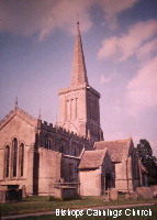
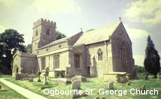
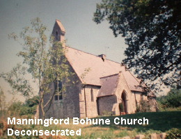
The name Temple Farm stems from the Knight's Templar who were founded in 1119 AD to protect pilgrims on their way to the Holy Land. The order was finally destroyed in 1307 AD by Philip The Fair of France after it had attained great wealth and power. During the course of its existence many lands were donated to the Templars, the farm here being on them being given by John Marshall an ancestor to the Earls of Pembroke. Returning back to you car leave Rockley and at the junction with the road to Marlborough turn right. Within a few hundred yards there is a left turn to Ogbourne Maizey. Take this road through the village until it meets the A.345. where you will need to turn left. This is a busy road, so care is needed, but about 1.3 miles along the road you will see a trackway opposite a turn to the village of Ogbourne St. Andrew. Turn and park here which takes you the spot of the centre of the eastern circle . This lies close to the join of this track with the position of the abandoned railway embankment. Leaving this point turn right and take the road to Ogbourne St. George which is signposted on the left hand side about 1.5 miles further on. Enter the village and at the next turning go left which will take you via a short road (0.8 miles) to the church which is signposted on the right hand side. Dedicated to St. George this church, as well as being on the circumference of the western circle is claimed to be part of the St. Michael alignment. The present church was built between the 12th to 15th century on the site of an earlier church. The church notes indicate that there was almost certainly a 'heathen temple' here before the original church was erected. Just back from the church in the village of Ogbourne there is a house owned by a friend, which lies on the circumference. Built into the corner of this house is a large undressed mark stone, which stands out clearly from the other coursed stonework. For Ogbourne access can be gained to the point where the alignment between the two centres intersects with the circumference of the western circle. To find the point return back to the centre of Ogbourne and turn left at the 'T' junction. The road will take you round the village and under the A.345. Immediately after the bridge you will see a roadway on the left hand side. Take this road, which follows the alignment of an old Roman road. You will pass a trackway crossing and a short way further on you will see a farm gate entrance on the left. If you park here it gives the approximate position of the intersection. From this place the East Kennet Long Barrow can be clearly seen as can the alignment through to the West Kennett Barrow. In the far distance the radio masts and the clump of trees on Furze Knoll marking the approximate edge of the western circle is visible on the skyline. This is the only place that I have found in the whole complex where it is very nearly possible to see right across the circles. To reach the next points you will need to retrace your steps back to the A.345 and take the road through to Marlborough. The earthworks has already been mentioned in the description of the eastern circle, but the tumuli can be found by taking the A.346 out of Marlborough. You will see a church on your left hand side after about 1.7 miles, and a further 1.3 miles along the road you will find a driveway access known as Sawpit Drive. Park here and walk up the drive until you meet a crossing with another trackway. Turn left here and a short walk of around 350 yards will take you to the site of a tumulus on the right hand side of the track. To find the next group of tumuli return back to Sawpit Drive and turn left. At the next main pathway turn left again. About 0.5 miles along this path you will come to another junction. At this point the group of tumuli are immediately in front of you in the 'v' made by the two trackways. The last but one point on the circle, before returning back to Bishops Cannings, is the Weslyan chapel in Pewsey. The chapel is not ancient being built in the last century but shows how modern religious buildings can often be found on 'leys'. This might of course be pure co-incidence for with all the new developments over the past one hundred and fifty years chance alone would predict that some sites of the is nature would coincide. I only mention this site here because it does fall on the circumference of the circle and readers can make there own assessments on whether it should be included or not. The last point is the de-consecrated church of Manningford Bohune Common, which has subsequently been turned into a private home. This can be found by taking the Woodborough road out of Pewsey. Just before this village, about 2.7 miles from Pewsey, there is a left turn over a railway bridge. Take this road and turn immediately left again over the bridge. Follow this road for a short distance and turn left again. The church site can be seen 300 yards up the road on the left hand side. Built in the last century the church does not appear to have ancient origins. However when excavations were being carried out to put in the septic tank for the new dwelling a much older series of burial sites, dating from the Middle Ages, were discovered which had not been marked on the diocesan map. The site had therefore been used, prior to the 1800's when the church was erected. The circle then returns to the church at Bishops Cannings completing the circuit.
Useful Links
follow on articles giving more details of other landscape
patterns.
|

David has been working as a healer, therapist and researcher for more than 40 years. He is the author of six books including The Healer Within and Working With Earth Energies
The definitive book on Working
With Earth Energies.
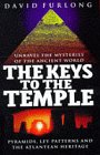
The book The Keys To The Temple from which the article is taken. Click the image for further details.
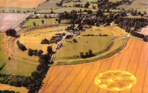
Click to enlarge The four church sites of: Avebury from the air. One of the key points on the Eastern Circle.
|
Home | Keys | Profile | Tours | Courses | Books | Articles | Calendar | Contact | Links
|
All material copyright David Furlong 2010 |