|
Training Courses
Tours
Online Videos
|
| Avebury - The Southern Inner Ring |
Counting the Stones of Outer Ring of the Southern Inner Circle
The full article can be downloaded as a .pdf. Please click here.
Abstract
As well as a vast outer circle the Avebury henge, in Wiltshire UK, contains two inner circles known as the Northern Inner Ring and the Southern Inner Ring. Both of these circles were largely destroyed in the 17 th and 18 th century with the development of the village of Avebury. This article re-examines the issue of the number of stones in the outer ring of the southern of these circles. William Stukeley in his book Abury a Temple of the British Druids with Some Others Described published in 1743 claimed that there were 30 stones in this ring (Stukeley, 1743). No one challenged this assumption until Isobel Smith, in her book Windmill Hill and Avebury: Excavations of A. Keiller, 1925-1939, published in 1965, which was based on her excavation work with Alexander Keiller, proposed 29 stones (Smith, 1965). English Heritage, in following Smith's lead, has affirmed a 29 stone circle (Malone, 1989). The problem with the southern circle is that most of its northern section was completely destroyed with the housing development of the village, so that the question of whether 29 or 30 stones existed in the original circle must be speculative. Nevertheless by carefully piecing together all of the evidence, in the light of recent technological developments, the most likely stone count and their approximate positions can be determined.
The article begins chronologically with a 'tour' description by Stukeley on what he saw and understood from his trips to Avebury between 1719 and 1724 (Piggott, 1985). It follows on by examining the evidence presented by Smith, indicating the possible reasons why she arrived at 29 stones, as well as highlighting some flaws in her argument. The evidence will then be weighed against Stukeley’s perception, providing some new insights en route, before concluding that Stukeley was most probably correct in asserting that there were 30 stones in the outer ring of this circle.
Stukeley's Tour description of the Southern Inner Circle - Background
As well as providing many maps and sketches Stukeley also gave a 'tour' description of the Southern Inner Ring, relating to the position of the stones as he perceived them to be in his visits. This narrative taken from Avebury Reconsidered (Stukeley, cited in Ucko et al, 1991 p.279) has a short commentary following each of Stukeley's individual stone descriptions. For reference purposes one of Stukeley's maps is shown in Fig.1.
Stukeley’s Description and Commentary
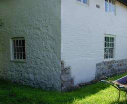
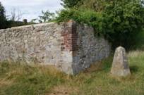
- Beginning in Pasture 1, entering from the Town Street where on the left hand is a garden wall built (of) the stone that stood in its place. [ This is the position of stone 1 from Keiller's plan and stone 109 in the modern idiom. It is now indicated by a concrete plinth erected by Keiller (Smith, 1965). The entrance to this pasture must have been similar position to the present gate opposite the Red Lion inn. Stukeley here suggests that the stone walling that runs alongside this entrance, which can still be seen today (Fig. 2), was composed of the broken parts of this stone.]
- Next to which are two hollow holes the seats of as many Stones of the outer circle of this temple. [Stones 2 (108) and 3 (107), which were excavated by Keiller (Smith, 1965), are at present marked by concrete plinths.]
- Three stones next are fallen but lie not much diminished; by the side of each is growing an ash tree, whence probably the stones were thrown down. [Stones 4 (106), 5 (105) and 6 (104): there is a discrepancy here between the plan and the description. In the plan ash trees are shown in front of stones 3, 4 and 5, not 4, 5 and 6. Stones 4 and 5 were re-erected by Keiller (Smith, 1965); stone 6 clearly still existed in a fallen state in Stukeley's time, but has since disappeared.]
- The next is standing, of a handsome figure. [Stone 7 (103) one of the original undisturbed stones.]
- Another lies along by the hedge side. [Stone 8 (102) was re-erected by Keiller (Smith, 1965).]
- Entering Pasture 2 the first stone is standing. [Stone 9 (101) this stone is due south of the Obelisk].
- The lodgement of the next is visible and a young ash tree planted in its room . [Stone 10, which had already gone in Stukeley’s day. The ash tree is shown in his plan.]
- The next has a little rising above the level of the ground. [Stone 11.]
- The next has a great cavity left and a young elm tree planted therein. [Stone 12: the cavity or depression here can still be seen.]
- The next to that is standing. [Stone 13 has now gone.]
- In pasture 3 the first is standing. [Stone 14 is no longer standing, although its position shows as a possible buried stone on the resistivity survey and has been marked on the NMR plan.]
- The 2nd has a hollow. [Stone 15 also shows as a possible buried stone on the NMR plan.]
- The next a perfect vacuity. [Stone 16 similarly shows as a possible buried stone on the NMR plan.]
|
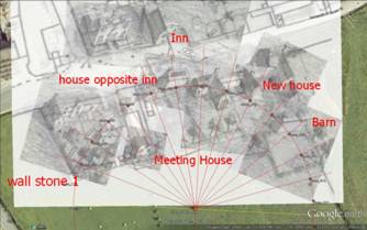
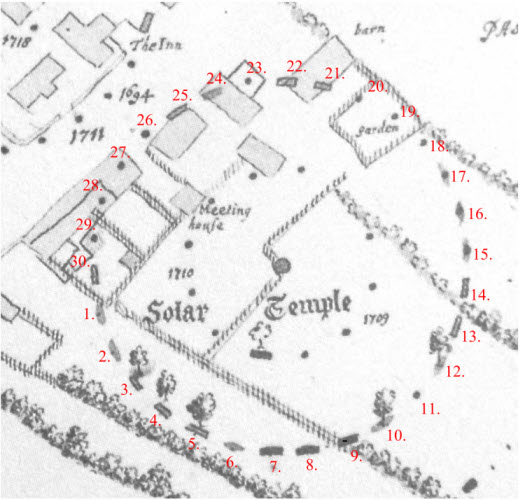
Fig. 1 - Stukeley Plan of the Southern Inner Circle
Taken from one of Stukeley’s early block maps dated to 1721 (Bodlein Library MS. Gough Maps 231, 22)
Solid blocks indicate extant stones, whilst the fainter blocks show stones that had fallen or where the stone holes were clearly visible. Assumed stone positions that had been fully destroyed are marked by a dot.
The plan shows 30 stones in the Southern Inner Ring and would appear to also relate to the description of the circle by Stukeley (Stukeley, cited in Ucko et al, 1991 p.279).
The plan shows the position of the Meeting House, opposite Silbury House. The position of the Catherine Wheel Inn is also shown with the house opposite, in the corner of which, Stukeley claimed, was one of the stones (25). |
- The next to that a very deep hole and great breadth. [Stone 17 (122): the depression here is also still clearly visible today and was re-measured as part of this study. From stone 1 to stone 17 Stukeley’s descriptions matches with the evidence that can be determined from different surveying techniques and their positions can be accurately determined. Any changes in the stone numbers must therefore occur with those stones that existed under the buildings or rear gardens that front Green Street.]
- The next stood by the pails of the garden. [Stone 18 would have stood close to the present garden fence. This position fits broadly with what has preceded so far with respect to spacing and is the probable position of this stone. Perhaps at one time the stone formed a natural boundary marker for the garden plot.]
- In that garden there were two. [Stone 19: Stukeley's plan (Fig. 1) and commentary, suggests two stones stood here. However when looking at his 3D plan in relationship to the 1886 OS map and on Google Earth (Fig. 2) only one stone could have existed in the garden plot. This might still exist, as a buried stone, in the most easterly property facing Green Street, known as Carpenter’s Cottage.]
- And two in the barn adjoining; one whereof remains in the floor . [Stones 20 and 21: The barn is clearly shown in Stukeley’s plan (Fig. 1). If one stone only existed in the garden then this would be stones 20 and 21. The first is drawn half way down the southern side of the barn and second on the northwest corner. It would seem that one stone had already disappeared, with the other still showing in some form. From the detailing in Stukeley’s plans it is not possible to say, which of the two stones might still have existed. Clearly the position of lost stones was not easy for him to determine.]
- The next destroyed since last year to build the next house. [Stone 22: Stukeley shows the barn as being over stone 22 but as suggested this is unlikely. The 1886 OS sheet shows a property over this placement, which has subsequently been demolished. It looks to have been in the rear garden of one of a pair of semi-detached properties known as 1 The Red Houses, Green Street.]
- One or two more did lie in the floor of that house. [Stones 23 and 24: two stones are shown in Fig. 1. The 1886 OS sheet shows properties here that have subsequently been demolished.]
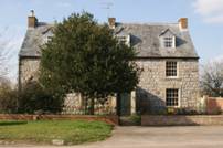
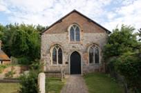
- The next lies now by the Street side under the corner of an house directly over against the inn. [Stone 25: Almost certainly this is part of the house known as 6 Green Street, which stands opposite the position of the Catherine Wheel Inn, where Stukeley stayed on his Avebury trips. This is considered in greater depth later in the article. In Stukeley's plans stone 25 is marked at the corner, or in front, of the detached cottage. There is a problem here in that the circle's projected circumference suggests the stone should have been close to its rear wall, not its front. However most of the side wall and part of the front of the present property is composed of stone, with the rest being brick. Is this what Stukeley saw? (See Fig. 2) This stone is also indicated on a plan by A.C. Smith published in 1881 (Smith, 1881). Stone count number 26 is shown as a dot on Stukeley's plan, suggesting that it had already been removed some years earlier.]
- The next that was in the garden was destroyed to build the meeting house. [Stone 27: The garden in front of the Meeting House can be readily identified as it still exists today. Stukeley shows the original building, with a double pitched roof, set close to the rear boundary fence, in the position of the present Victorian extension. The oldest part of the present chapel must have been built soon after Stukeley's time, which is probably why the stone that stood there had been removed. The possible position of this stone could have been picked up in the archaeological report [Oxford Archaeology, 2002] from the work carried out at the Meeting House in 2002. If so the stone would have been close to the northwest corner of the present main building.]
- The next is left in a barn or stable floor. [Stone 28: Stukeley’s comment here suggests that this stone might still have existed in some form in his time.]
- The next stood in a garden but now demolished. [Stone 29: the position of this stone is shown on Gray's plan dated to 1908 (Gray, 1935). It was first recorded by A. C. Smith in 1884 when he states :
"I have also to record that a large stone, which would have occupied a north-western portion in the southern temple, once stood in the garden of Mr Pratt, where a plum tree now stands; and that this stone is recollected by Robert Clements and other inhabitants of Abury, though it was destroyed years ago." (Smith A.C., 1884).
There is an anomaly here in that Stukeley suggests that the stone was “now demolished” and his plan in Fig. 1 shows it simply as a dot (missing stone); whilst Smith suggests that the stone could be remembered by villagers, probably a hundred years after Stukeley. In other of Stukeley’s plans the stone is indicated as recumbent so perhaps he initially missed seeing it.]
- The last is at present buried in the same garden, which completes our number of 30. [Stone 30: could there still be a buried stone in the rear garden on the most western property in Green Street?]
The above is an introduction and summary. The full article can be downloaded in .pdf format by clicking the following link:
Avebury's Southern Circle: Counting the Stones in the Outer Ring.
For .pdf report on Carpenter Cottage, Avebury: Geophysical Survey please click here
Useful Links
follow on articles giving more details of other landscape
patterns.
Twin circles of the
Marlborough Downs explores sacred patterns of Wiltshire
Marlborough Downs
Sites a tour of the sites that make up the twin circle pattern
The Cotswold Circle an
article on a similar sized circle that over-lights the Cotswold area
The Hidden Geometry of
Avebury a look at the hidden geometry of Avebury
Silbury Hill and the Sanctuary an article on
significance of Silbury Hill and the Sanctuary
The Keys to
the Temple information on the book The Keys to the Temple by David Furlong
|
For further information please write to:
David Furlong Myrtles, Como Road, Malvern Worcs WR14 2TH
Tel: +44 (0)1684-569105 or Mobile: + 44 (0)777-978-9047
Email:
David Furlong |
|

David has been working as a healer, therapist and researcher for more than 40 years. He is the author of six books including The Healer Within and Working With Earth Energies
To contact David click here
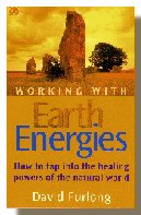
The definitive book on Working
With Earth Energies.
Click here for more
details.
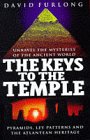
The book The Keys To The Temple from which the article is taken. Click the image for further details.
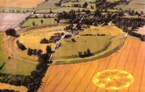
Avebury from the air. One of the key points on the Eastern Circle.
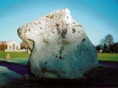
Part of the Avebury Henge
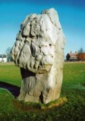
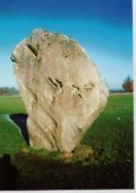
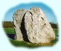
Avebury Stones
|