Egyptian Temple Orientation
Astronomical Alignment in the Temples of Egypt
by David Furlong
Part 1
Abstract
This paper considers the possible astronomical orientation of eleven temple sites in Upper Egypt. These are:
Karnak:
1. Main Amun Temple (Ipet Isut)
2. Mut Temple
3. Ptah Temple
Luxor:
1. Amenhotep III Temple
2. Ramses II temple + Avenue of Sphinxes
Deir El Bahari:
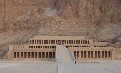
Hatshepsut Temple (general)
Hatshepsut Temple - Solstice Alignment detail
Medinet Habu:
Ramses III Temple
Qurna:
1. Seti 1 Temple
2. Amenhotep III Temple
Denderah:
Hathor Temple
Edfu:
Horus Temple
It suggests that many, though not all, of these temples can be shown to align to significant astronomical events that includes the mid-winter sunrise; the southern major standstill of the Moon and in some cases to either stars or constellations. In the context of all of the temples of Upper Egypt this is but a small sample. Nevertheless it does support the view that astronomical alignment played a significant part in the orientation of some temples. The study makes use of modern computing techniques that includes the Google Earth mapping programme.
(This article runs over six pages. To download the whole article in pdf format please click here)
Background
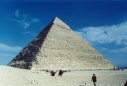
Since Sir Norman Lockyer first published his discoveries in his book The Dawn of Astronomy (1894) highlighting the possible astronomical alignment of Egyptian temples, there has been unresolved speculation about their orientation. Researchers that have stood in the arrow straight avenue of the central aisle of the vast temple of Amun at Karnak or the looked out from the inner sanctuary of a temple like that of Hathor at Denderah cannot help but have wondered at the alignment intention of their Ancient Egyptian builders. We know that the Egyptians were competent surveyors , a skill required by the annual flooding of the Nile, which destroyed the crop and land boundaries every season. They were also clearly capable of very accurate orientation to the cardinal points of the compass as evidence in the construction of the Old Kingdom pyramids , yet the temple orientation has proved more problematic for a number of very good reasons.
Firstly before the advent of modern computing and GPS technology calculating the exact azimuth alignment of a temple was not an easy matter. To be fully accurate requires sophisticated surveying techniques using a prismatic compass combined with careful theodolite observation to the stars. All of this would need to be backed up by some extensive mathematical calculations. One only has to read about Petrie’s two year survey of the Giza plateau to appreciate what a time consuming task this would be.
Secondly, since the time of the pharaohs, the star positions have changed considerably in their precessional orbits. Although solar and lunar alignments would still work today, assessing stellar alignments would require a further set of complicated calculations. This range of skills lies beyond the normal Egyptologist and as such a study of the astronomic alignment of the temples never gained much favour.
Computers have completely changed this situation. With mapping programmes such as Google Earth and astronomical programmes like Redshift, Starry Night or StarCalc it is now possible for anybody with a little understanding to both assess temple orientations as well as consider the night skies of the Ancient Egyptians. This present study draws heavily upon such resources. The advantage of this approach is that anyone with the necessary programmes can easily check these findings for themselves.
Shaltout and Belmonte Study on the Orientation of Egyptian Temples
This paper also draws upon a detailed study carried out in 2005 by M Shaltout and J.A Belmonte entitled the Orientation of Ancient Egyptian Temples 1: Upper Egypt and Lower Nubia . This study has catalogued one hundred and thirty-three temple sites, in probably the most extensive single survey of this type carried out on the Egyptian temples. The methods used for checking the azimuths were based on prismatic compass readings, which the authors claim are accurate to within ± ½°. These readings are compared within this present study with those based on map projections. The Shaltout and Belmonte study looks, in some depth, at four different temple sites, which support a link between temple orientation and astronomical events, the most notable of which is towards the mid-winter sunrise. The calculated azimuths within this present work can be calibrated to minutes and seconds of arc . However I would not want to claim a greater level of accuracy than that given by Shaltout and Belmonte.
Hereafter this study will be referred to as SB or the SB study. Details of this study can be found at: ftp://ftp.ll.iac.es/pub/research/preprints/PP05003.pdf
Potential Astronomical Alignments
If we discount the planets, astronomical alignments fall into three main categories:
· Solar
· Lunar
· Stellar
The Sun
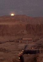
Solar alignments principally include the solstices of mid-summer and mid-winter as well as the spring and autumn equinoxes. In practice these latter alignments rarely feature in ancient monuments because of the difficulty of their accurate assessment . Mid-winter and mid-summer sunrises and sunsets, when the Sun stands still, the true meaning of the word solstice, are by far the most common solar phenomena to be observed and recorded. Falling annually these can be easily checked by site observation on the relevant days. As has been shown with so many ancient monuments, the Sun alignments still work today with the same precision perceived many thousands of years ago.
In the case of Egypt there is one other well known solar alignment that attracts many hundreds of visitors each year. It is to be found at the temple of Abu Simbel built by Ramses II as a cult temple to himself. Despite being rescued in 1972 from the rising waters behind the Aswan dam, the solar illumination of the inner sanctuary of the temple can be still be witnessed today around 22nd of February and October each year . These two dates do not mark any specific solar position and are relevant only to the Ramses temple and his cult status as a god.
The solar alignments for Luxor can be shown as:
· Mid-winter sunrise - 117°
· Mid-winter sunset - 243° (In practice this would be affected by the proximity of the Theban hills)
· Mid-summer sunrise - 64°
· Mid-summer sunset - 297°(In practice this would be affected by the proximity of the Theban hills)
All temples in Upper Egypt would fall within a degree of these figures assuming a level horizon. Actual site azimuths are always dependent upon the exact height of the horizon when viewed from a temple.
The Moon
The lunar cycles are much more complex. They oscillate over a period of 19 years known as the Metonic cycle, named after the 5th century bc Greek astronomer Meton . Unlike the Sun, whose measured progress across the horizon can be checked on a daily basis the Moons movements appear more erratic, rising and setting in what appears to be arbitrary positions each day. Effectively it swings back and forth across the ecliptic over the space of one month, as opposed to the Suns annual journey, which is why the Ancient Egyptians called this celestial body the wander. Like the Sun the Moon does eventually reach an extreme northerly and southerly position, where the amplitude of the swing is at its greatest, but only after 254 synodic months, the Metonic cycle. We have four relevant principle positions which involve both the rising and setting positions of the Moon.
· Northernmost major standstill (most northerly limit of the Moon’s position)
· Northernmost minor standstill
· Southernmost minor standstill
· Southernmost major standstill (most southerly limit of the Moon’s position)
Half way through the nineteen year cycle of the maximum amplitude of the swing, the oscillation is at its smallest. This is known as the minor standstill position. This effectively means that there are eight potential sighting positions for the Moon if we include both its rising and setting azimuths. There is evidence that monuments like Stonehenge in Wiltshire, England and a number of sites in Scotland such as Caithness accurately measured some of these positions . Like the Sun alignments, lunar alignments still work today, although observing them is often much more difficult, because the cycles are much longer.
There is no accepted textual evidence that the Ancient Egyptians were able to predict eclipses and by inference then the Metonic cycle, although there is no practical reason why the lunar movements could not have been part of Egyptian temple orientation. Certainly the Moon took less precedence than the Sun in Egyptian mythology, nevertheless it was still regarded as an important body and there were a number of gods such as Thoth, Khonsu and Iah that were associated with it. As we shall see there is evidence of the possibility of more than one temple being aligned to one or other of the major lunar standstills.
The Stars
The stellar map of the sky, consistent on an annual basis, only slowly changes through a process known as precession. This is where the stars rotate in relation to the Earth over a period of time of approximately twenty-six thousand years . In practice the rising position of a star, in the course of the average life span, moves by about one degree. Effectively then, any star observations used at the setting out of a temple, known as the stretching of the cord or pedj shes , would no longer be relevant several hundred years later. Because the regnum dates of the different kings are known it is possible to work out the construction dates of their mortuary temples at least within a few years. Cult temples, dedicated to a specific god or goddess, are another matter for we can never be fully sure when the orientation of a temple was established, even if the construction date of the extant temple is known. It might well have been set by an earlier temple built on the same site. Therefore stellar orientations, without textual corroboration, have to remain speculative. However, even here, as we shall see at Denderah, textual information might still not tell the whole story.
Problems
There are a number of problems that confront any study looking at deliberate astronomical orientation of the temples of Egypt. Firstly it is clear that the Ancient Egyptians were not consistent in their temples alignments, which point to many different azimuths and as such to different potential astronomical events . In the case of stellar alignments, the most obvious contenders are the first magnitude stars like Sirius, Canopus, Vega and Arcturus, although constellation groupings like Orion, Cassiopeia and Ursa Major could also have been used. Unless the dating of a temple is accurately known possible star orientations can be notoriously difficult to assess. Time changes of several hundred years can considerably alter potential stellar alignments.
On another level computer assessments are only as good as the algorithms that have been woven into them. As these become more sophisticated the possibility for error becomes reduced, nevertheless the potential for inaccuracy is still there. In assessing several different astronomical software programs as part of this paper, differences of several degrees were found in star declinations, particularly when travelling back in time to the Ancient Egyptian epoch. Cross checking between programmes can help to minimise these errors . What this principally affects, in the case of all stellar orientations, is the precise dating of the monument or alignment orientation .
The alignments that can be easily checked today are those connected to the Sun, of which the winter solstice is most in evidence. It occurs in three of our study sites and potentially in a further five temples in the SB study.
Finally this article principally considers astronomical alignments, although it does offer some suggestions for the alignment, when the astronomical events are not apparent. It does not preclude the possibility that other factors, such as the position of the Nile or an alignment to a specific site feature might have been the primary reason for a particular temple orientation.
Methodology
Using the sophisticated tools of today the correct way to check the azimuth of a temple orientation would be to take a series of GPS readings at say the mid point at the back of the temple (point A); move forward to a second position on the axis of the temple, such as the front entrance and then take a further series of readings at the new location (point B). These readings can then be calibrated with a local GPS base stations to provide exact latitude and longitude co-ordinates for (A) and (B). It is then possible to calculate accurately the bearing between these two points. This is how all modern mapping is carried out . Even so to do this accurately for each temple site would entail many onsite observations.
Fortunately there is now a simplified way to get around this problem, yet still providing a sufficient level of accuracy to assess the potential astronomical alignment of a temple. This is by using a similar technique based on the alignment projections from a computer mapping programme like Google Earth . In the case of Egypt the clarity is sufficiently good to be able to project temple orientations, in some cases over several kilometres and then take the latitude and longitude co-ordinates at the two terminal points. These projections have been backed up, on occasions, with GPS readings taken on site visits in Egypt . The alignments revealed using this method correspond reasonably closely with the SB study that used a prismatic compass. Where differences occur these have been highlighted.
Explaining, why differences should have occurred in some cases between these two methods is a little more complex. It is clear that in broad terms the azimuths discovered from the map projections, whether north/south (Edfu temple to Horus) or east/west (Karnak Temple) conform sufficiently closely to validate the findings of both methods. The differences where they occur could be down to minor variations, within a temple complex, not obviously perceived from a map projection.
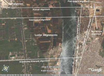
Plan 3 (From Google Earth Mapping Service/image©2007 DigitalGlobe)
Plan of the Luxor area showing the alignment projections from the different temple sites. The alignments from the temples of Karnak, Hatshepsut and Amenhotep III are all related to the mid-winter sunrise. The alignment from Seti I temple and the Ptah temple relate to the southernmost major standstill of the Moon. Note also that the alignment from the Luxor temple runs parallel with the Nile. It was this feature the probably determined the axis of the temple.
Temple Alignments
Please click the links to go through to the relevant temple or follow the next button.
Solar:
Amun temple at Karnak
Hatshepsut temple at Deir El Bahari
Amenhotep III temple at Qurna
Lunar:
Seti I temple at Qurna
Ptah temple at Karnak
Stellar:
Ramses III temple Medinet Habu
Mut temple at Karnak
Amenhotep III temple at Luxor
Ramses II temple at Luxor
Hathor temple at Denderah
Horus temple at Edfu

Computer Programmes
Astronomy Programmes
Starry Night Complete Space and Astronomy Park Deluxe Edition 6
Red Shift Deluxe Edition 5.1
StarCalc ver 5.73
MyStars ver 2.7
Mapping
Google Earth Plus ver 3.0.0762
Azimuth Calculator
http://www.wherearewe.co.nz/greatcircle.html
Plans
Plans of the different Temple sites taken from Google Earth mapping Programme.
See http://earth.google.com/download-earth.html
|
For further information please write to:
David Furlong
Myrtles, Como Road, Malvern Worcs WR14 2TH
or phone 01684-569105 or 07779789047
Email:
David Furlong |
|